A comparison of GeoSafe's flood exposure screening with official Grand River Conservation Authority floodplain mapping — demonstrating how site-level screening adds context beyond the regulatory boundary.
Regulatory floodplain mapping defines where development controls and conservation authority review may apply. However, translating those boundaries into practical risk decisions requires an additional layer of interpretation.
This case study compares GeoSafe's flood exposure screening with the Grand River Conservation Authority's official floodplain mapping for the Kitchener urban corridor. The result is a clearer path from regulatory awareness to practical flood exposure screening.
Key finding
GRCA mapping defines the regulatory boundary. GeoSafe helps users better understand potential exposure within and around mapped flood-prone areas.
GeoSafe's simulated impact area (left) compared with official GRCA regulatory floodplain mapping (right) — Kitchener, Ontario, Grand River urban corridor.
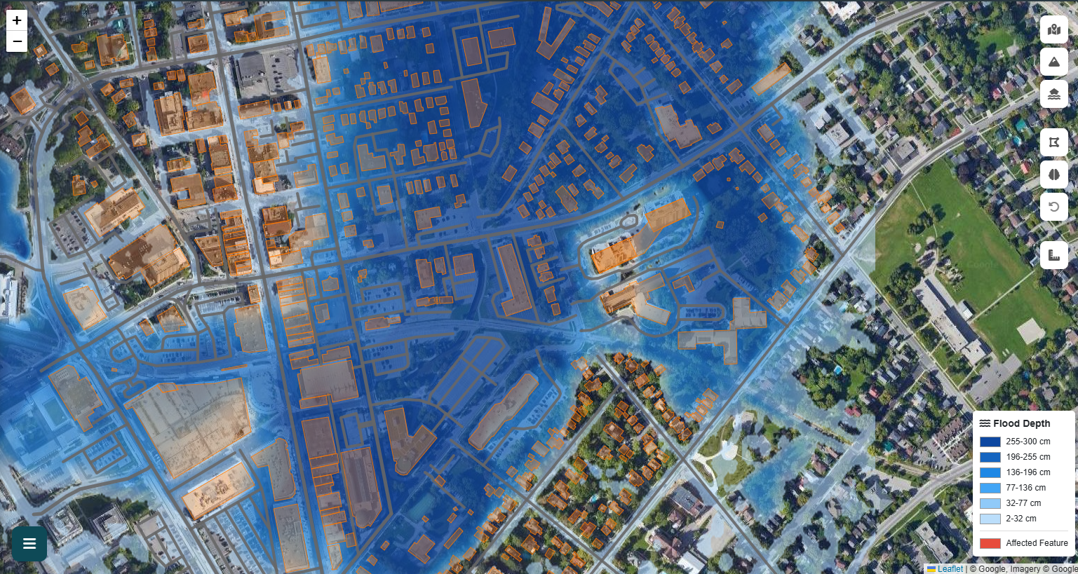
Flood exposure screening showing relative depth zones, buildings, roads, and infrastructure that may be affected across the Grand River urban corridor in Kitchener.
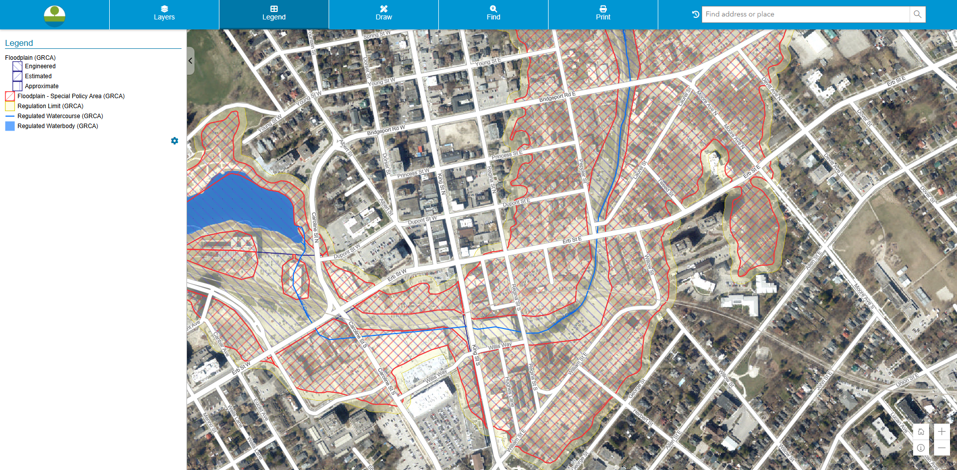
Grand River Conservation Authority regulatory map showing engineered and estimated floodplain boundaries, Special Policy Areas, regulation limits, regulated watercourses, and regulated waterbodies.
Spatial consistency note: Visual comparison shows that GeoSafe's simulated impact area generally follows the low-lying corridor represented in GRCA floodplain mapping. This agreement suggests GeoSafe can identify a broadly similar flood-prone spatial pattern while adding practical site-level context beyond the regulatory boundary. This comparison should be treated as screening-level evidence of spatial consistency — it does not replace formal hydraulic model calibration or conservation authority review.
How the two mapping approaches differ in purpose, output, and decision value.
| Feature | GRCA Regulatory Mapping | GeoSafe Impact Simulation |
|---|---|---|
| Primary purpose | Planning, permitting, and regulatory compliance | Exposure screening and planning support |
| Main question answered | Is this area within or near a regulated zone? | What assets may require additional review? |
| Visual output | Defined boundaries and regulation limits | Simulation-based flood-impact visualization over imagery |
| Asset screening | Broad area-based interpretation | Building and infrastructure screening |
| Decision value | Supports official review and compliance | Supports planning discussions and further review |
GeoSafe translates mapped flood exposure into site-level context that complements regulatory data.
GeoSafe goes beyond the boundary by helping users understand not only where floodplain regulation may apply, but also how flood exposure may affect real assets on the ground — with estimated depth zones, building exposure screening, and planning considerations.
For this Kitchener study area: GeoSafe identified individual buildings, road segments, and infrastructure exposed at varying flood depths — information not directly available from the regulatory boundary map alone.
| GeoSafe Function | Practical Value |
|---|---|
| Built-environment visualization | Helps users understand where impacts may occur at the building and street level |
| Asset-level screening | Identifies specific buildings, roads, and features requiring closer review |
| Access-route analysis | Supports emergency response planning and operational continuity assessment |
| Estimated depth interpretation | Helps distinguish lower-concern areas from higher-concern areas by flood severity |
| Planning considerations | Supports planning discussions and identifies where further professional review may be warranted |
GeoSafe is a decision-support and flood-risk screening tool. It is not a replacement for official conservation authority mapping, regulatory floodplain studies, or site-specific engineering design.
GeoSafe outputs are intended for preliminary assessment, risk visualization, planning support, and communication. For planning approvals, permitting, legal development applications, and conservation authority review, users must refer to official regulatory mapping and consult the appropriate authority — including the GRCA where applicable.
GeoSafe simulation results should be interpreted by qualified professionals before being used for final engineering, insurance, investment, or emergency-management decisions.
GeoSafe is intended as a screening and decision-support platform. Results are dependent on available datasets, modeling assumptions, and user inputs.
Data sources: GRCA regulatory mapping via Grand River Conservation Authority geospatial portal. GeoSafe assessment based on publicly available Canadian terrain, weather, building, infrastructure, and hazard datasets.
GeoSafe can generate a comparable flood-impact assessment for any location across Canada in minutes.
Get Started Free Request a Quote